Tag Archives: species tracker

Low sea ice spells trouble for Svalbard bears

[Updated, April 15, 2016] The past year has broken records for warmth in the Arctic, and around the world. First, 2015 was the warmest year on record. Then January 2016 smashed global records to become the hottest January. February 2016 was the hottest February ever recorded, and the most abnormally warm month, breaking a record set just two months earlier.
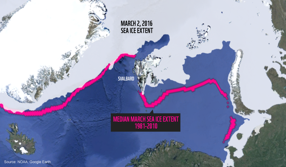
Around this time of year, sea ice in the Arctic generally reaches is maximum extent before beginning its summer melt. But not surprisingly, sea ice has also broken records. The ice hit a maximum of 14.52 million km2 on March 24. This is the lowest winter maximum ever recorded, beating the previous low maximum set last year.
Svalbard, an archipelago in Norway’s high Arctic, was one of the most anomalously hot places on earth this year. It’s also home to a large and well-researched polar bear population. Polar bears rely on sea ice to hunt for seals, their preferred prey. This year, sea ice was missing from much of the archipelago.


Since 2003, WWF has tracked Svalbard polar bears by satellite. We talked to Jon Aars, a polar bear biologist with the Norwegian Polar Institute to find out what’s happening with the bears we’re following.
Jon tells us that last summer, the bears were in good condition – there was plenty of ice, and it melted late, particularly around eastern Svalbard. This year’s low ice levels mean the bears could have much less time to hunt, making for a challenging year.
 

Listen: WWF’s Clive Tesar interviews Jon Aars of the Norwegian Polar Institute about this winter’s extreme melt.

North Svalbard

Two polar bears on shore in northern Svalbard. Normally, this area would be completely ice covered in March.

Two polar bears on shore in northern Svalbard. Normally, this area would be completely ice covered in March.


This year, we’re tracking two bears in the north. One, N26165 (blue), is currently in  a den. There’s now a small amount of ice in the vicinity of her den, but it’s hard to tell how long it will stick around. Mother bears tend to be thin and hungry when they emerge from dens – giving birth and nursing cubs takes a lot of energy. They are at a disadvantage if there isn’t plenty of ice – ringed seal habitat – around when they emerge in the spring.
The other, N26243 (orange), headed up on the ice early in the season. But as the ice disappeared, she headed back to the coast. She waited around for ice before moving west.
In past years, we’ve also tracked bears who have gone far out onto the sea ice. Isdimma2’s collar stopped functioning in June 2015, so we don’t know if she managed to make it back to Svalbard this year to den or spend the winter.

West Svalbard

This mother and daughter have had very little access to sea ice this year.

This mother and daughter have had very little access to sea ice this year.


A mother bear, N23979 (orange) and her adult daughter N23980 (green) have had very little access to sea ice this winter. N23980 has been seen feeding on goose eggs and harbor seals in the summer, but she would ideally have access to ice and ringed seals by now.

Making the situation more challenging, N23979 has a history of getting into trouble with people. Here and elsewhere in the Arctic, polar bears driven ashore by a lack of ice have come into communities in search of food. According to NPI researcher Magnus Andersen, several years ago she was tranquillized and moved away after breaking into several cabins close to a settlement. Currently, she is in an area with quite a few cabins that she might find interesting – let’s hope she stays out of trouble.

“In western and northern areas there is still very little ice”, says Jon, “and cold weather for the next couple of months will be important for the bears.”.
 

The strange case of Green Bear

Around the world, polar bear researchers use satellite collars to track where bears go, and how they’re adapting to a fast-changing Arctic. We follow a number of these bears on an interactive map:

Because the data is (almost) live, you can watch unusual and exciting behaviour unfold as the researchers do.
This year, researchers at the University of Alberta watched a polar bear mother and cub with interest.
Polar bears in Canada’s Western and Southern Hudson Bay tend to stick to a script – they wait on shore each fall for the ice (and seals) to return, and spend the winter gorging on as many seals as possible. Then spring ice breakup forces them back to shore, where they have little opportunity to eat until the ice returns.
X12777, aka Green Bear, seemed to have a different idea:

Track of bear X12777, Hudson Bay, Canada

Track of bear X12777, Hudson Bay, Canada


Although the 19 polar bear populations are generally well-defined, boundaries shift and bears move between populations from time to time. But to date, no polar bear from Western Hudson Bay had been observed to move so far east.
However, this bear’s journey was not as exciting as it first seemed. The researchers soon realized that the signals sent by the bear collar matched the trajectory of the sea ice – in other words, the collar was no longer attached to a moving bear, and was simply floating along on the melting ice.
Satellite collars can fall off prematurely if, for example, they are unusually loose or the internal clock of the collar is wrong, triggering the release mechanism early. We hope that’s what happened here, although it’s also possible that the bear has succumbed to illness or injury.
If she’s still healthy, we may encounter her again. Each bear receives a permanent tattoo on its lip, so researchers can recognize it, and understand how the bear’s health and condition changes over time in response to its environment.
Although Green Bear’s story is over for now, there are more polar bear tracks to follow:
In Western Hudson Bay, Purple and Blue are finishing a season on the ice and heading back to shore. Follow them on our map here.
And on Svalbard, four new bears (and their cubs) are starting their summer journeys. Follow along here.

April 2015: Bowheads in spring

We’ve followed a group of satellite-tagged Bowhead whales in northern Canada for 2 years. Our Arctic whale expert, Pete Ewins, explains what the whales are up to.

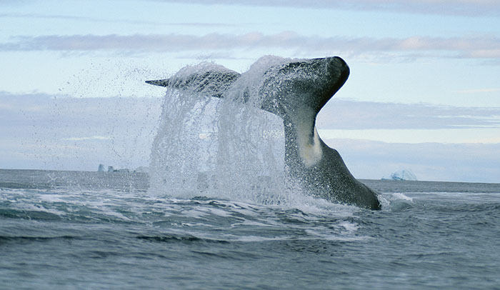
File photograph of a bowhead whale. Photo: WWF/Paul Nicklen, National Geographic Stock

File photograph of a bowhead whale. Photo: WWF/Paul Nicklen, National Geographic Stock


From the batch of Bowhead whales fitted with satellite radio tags in northern Foxe Basin in July 2013, amazingly a few of them still have working radios – coming up for nearly 2 full years of hugely valuable information on both daily positions/movements, but also details of dive times and depths!  These data are crucial for informing accelerating decisions about industrial activities in these same sensitive and rapidly changing marine systems.
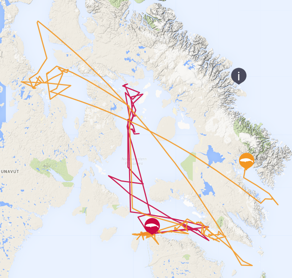
Let’s look at two individuals in particular – 128152 (Orange), and 128150 (Red).
Location of bowhead whales in April 2015

Location of bowhead whales in April 2015


Go to interactive map

Red and Orange spent winter of 2013-14 in Hudson Strait, and like other bowheads, generally moved from east to west over the course of  the winter – associating with the predictable areas of broken ice and the relatively strong currents present there.
By late winter (March-April), it looks like the area off Digges and Mansel Islands near Ivujivik may be a very important regularly used habitat, towards the edge of the deepwater channel in central western Hudson Strait. Both of these whales headed back after May-June 2014 to Foxe Basin / the Gulf of Boothia.  But Orange has wintered in 2014-15 in an entirely different area – Cumberland Sound, SE Baffin Island, moving steadily in towards the upper reaches of this huge sound by early April.
Examination of the daily sea-ice charts shows that this whale is sticking to areas of broken ice, with plenty of opportunities for breathing.  It’s not thought that these whales are doing much feeding at this time of year. But the spring flush of light, energy and nutrient rich water will start soon, and these whales will capitalize for sure when they encounter large concentrations of copepods, their preferred krill-like food.
Why are these data really important for bowhead whale conservation? Well, as bowhead whale populations are still recovering slowly, but steadily, from the huge declines resulting from heavy commercial over-harvesting since the 18th century, it is important to manage all human activities that present further risks.  Obviously for an ice-dependent whale like this, that means first and foremost rapid climate change and the ongoing retreat and thinning of sea-ice. March 2015 saw the record lowest cover of Arctic sea-ice since records began back in the 1970s.
All part of the projected trends, given the trends in global greenhouse gas emissions.
But on top of this major pressure, increased shipping and explorations from the oil & gas industry, presents greater and new risks of oil spills, noise disruption and displacement of marine mammals from key habitats, and of course actual ship strikes of resting whales.
This is where these data gathered from high-tech satellite tags comes in – they can be hugely important in confirming the main areas used by these sensitive marine mammals at different times of year.  And then industrial projects can plan to avoid and minimize their impact on such important wildlife resources.
WWF is working hard with as many parties as possible to help plan for a healthy low-risk future, that can balance the needs of key wildlife species with the needs of local communities and a healthy economy.  But in these circumstances, this means taking new approaches.  That is what we continue to help develop.

Walk 3,700 km with a polar bear

We’ve followed dozens of polar bears on the WWF Polar Bear Tracker since it launched in 2003. But few have wandered as far as Kara, a female bear tagged by researchers in Spring 2013.
By fitting polar bears with GPS collars (females only – the collars slip off the males’ larger necks), researchers from the Norwegian Polar Institute can track exactly where the bears of Svalbard go. After years of such work, the researchers get to know many of the individual bears. Sometimes, however, previously unencountered bears appear on Svalbard. Unlike local bears that spend the summers hunting seals in Svalbard’s fjords, these bears may be long-distance wanderers on the sea ice – “pelagic” polar bears.

See her journey on the ice

Explore Kara’s journey on the interactive map:

Understanding long-distance polar bears

Most of Svalbard’s polar bears remain on land throughout the summer, a strategy that requires less energy than long-distance roaming. On land, however, there is less food in the summer. Why do bears choose one strategy over the other? Tracking the bears will help NPI answer questions like:

  • Do individual polar bears shift strategy between years?
  • Do cubs learn from their mothers whether to walk the sea ice or to stay on land?
  • Are the Svalbard polar bears split between Russian-oriented and Greenland-oriented individuals? Some wandering polar bears head east like Kara. Other wanderers seem to prefer to head north and west like N26220, who was collared April 2014.

Research over long periods of time is vital to polar bear conservation. By understanding how they use their habitat, what places appear to be important for them and how populations change, only then we can arrange for better protection measures.

June 2014: Bowheads and breaking ice

Bowhead with tracking device. © Bernard LeBlanc.

Bowhead with tracking device. © Bernard LeBlanc.


Arctic whale specialist Pete Ewins gives us an update on the bowhead whales being tracked by Nunavut Wildlife Management Board and the Department of Fisheries and Oceans, Canada.
As southern Canada starts switching on the air conditioning units and breaking out the fans in late June, the Arctic sea-ice is still there according to the satellite snapshots. But such technology can now tell us even the depth of the sea-ice – and that is what counts at least as much as the area of ocean with ice cover, at least from the point of view of marine wildlife like the ice-evolved bowhead whale! Especially towards the southern edges of the ‘Arctic’ sea-ice thickness has been dropping dramatically in the past decade – meaning that it melts earlier each spring, which increases the length of the open-water summer period.

The amazing compact technology now packed into a mobile-phone sized transmitter unit, and attached to the 100-tonne bowhead whales, has in recent years been able to give conservation science and decision-makers alike invaluable facts about where the whales spend their time, and hence help identify and protect these most special areas.
The stunning news this month is that bowhead whale 114495 (currently off Southeast Baffin Island in areas of ever-opening summer Arctic ocean) has had its radio transmitter device on for 2 years now – and its still transmitting vital information back to the scientists via orbiting satellites.
WWF is excited to be able to help share these spatial data. These whales move a lot, but they home-in on a relatively small number of very special areas for doing key things like raising their dependent young, feeding, and resting safely well out of reach from their main predator – killer whales.
Knowing where these key areas are for bowheads and other magnificent Arctic wildlife still in their natural habitats is crucial as our society plans for future increased human activities like commercial shipping, oil-gas exploration, and large-scale mining and ore shipment, and commercial fishing.

Svalbard bear update – N26135

In April 2013, our partners at the Norwegian Polar Institute (NPI) began tracking a number of polar bears on Svalbard using GPS-enabled collars.  Here, NPI’s Magnus Andersen updates us on their behaviours. See all bears on the Polar Bear Tracker.

Kara, aka N26135, was tagged in Svalbard in spring. During the summer and autumn months, she performed a record long journey from Svalbard past Franz Josef Land in Russia and all the way to Severnaya Zemlja.
When the sea ice cover was at the minimum in late September she went on shore at Severnaya Zemlja, but as soon as the sea ice again started to form and grow towards the south she started to move across the northern Kara Sea towards the Franz Josef Land Archipelago. In the end of November she reached one of the easternmost islands in the archipelago, Graham Bell Island.
Once on the island it seems like she dug a den, stayed in it for some time and then possibly moved to another den location for some unknown reason. After yet a while we stopped receiving positions, either because the transmissions were blocked by snow and the terrain or simply because the electronics stopped functioning.
 

January 2014: Where are the bowheads now?

Arctic whale specialist Pete Ewins gives us an update on the bowhead whales being tracked by Nunavut Wildlife Management Board and the Department of Fisheries and Oceans, Canada.

The new year started with another impressive map for all the bowheads still with working satellite radio tags, yeah! As the sea ice continues to thicken and extend southwards, the bowhead are concentrating in areas they’re familiar with from previous years, where there’s ample ice movement and large leads (cracks) for breathing.
For anyone that inspects the Canadian Ice Service maps  for this region, you’d be forgiven for being a bit puzzled.  The area where most of these bowhead whales are this week, just N and NE of Charles Island, just NE of Salluit and Deception Bay,  seems to be at the maximum ice cover – 9-10/10ths.  Well, that’s right!  These whales love to be close to and among  the heavy annual sea-ice.  Their huge reinforced heads and the rostrum, and lack of a dorsal fin, enable them to break ice a few feet thick if they need to, so that’s how this species has evolved over tens of thousands of years!  The 3 bowheads to the east of Iqaluit /Baffin Island are in an area of broken/patchy sea-ice, at the edge of the open water in Davis Strait.  All will be well clear of any predatory Killer Whales that may be still hanging around these regions.  (Overnight temperatures in Salluit-Hudson Strait region are around -30C now).
Of course we can’t travel to these areas, so we rely heavily on this fabulous technology to beam the locations back to our computers!  Beyond simply tracking the whale movements, the aggregated information over a season and then over years helps resource managers and scientists produce a well-informed picture of the key areas used by these magnificent whales as they over-winter.  And in the face of increasing industrial development activities (like commercial shipping, oil & gas, and fishing) it is vital to know where these key areas are, and then to put  all the measures in place to truly protect them from adverse impacts of human activities, especially in these high risk arctic marine environments.
Learn more about bowhead whales


When bears come to town

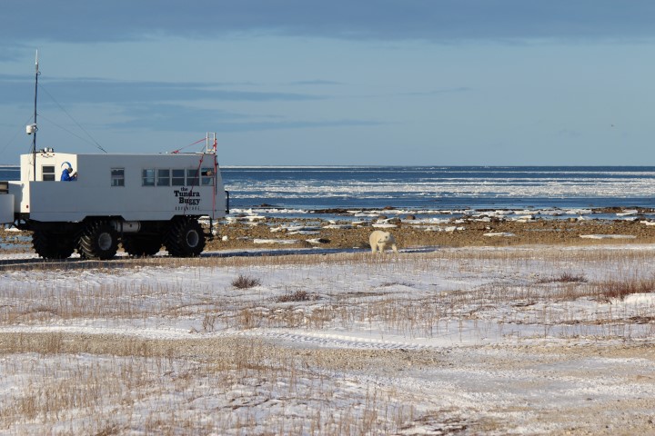
A polar bear approaches a tundra buggy in Churchill, Manitoba. © Geoff York / WWF

A polar bear approaches a tundra buggy in Churchill, Manitoba. © Geoff York / WWF


The temperatures and winds are dropping nicely this morning. New slush ice is quickly forming again along the shores of the Bay as I sip my coffee and quickly check my email (yes- even in the far north and miles from any town, we have internet!).
One email is an update from our research partners at the University of Alberta. WWF has funded polar bear research through UAB for many years in Canada. Our conservation partners and members allow us to add critical funds that help make larger research projects whole or that add potential for graduate student involvement- training the polar bear researchers and mangers of tomorrow.
For those of you who follow our Polar bear Tracker  site, the data from the West Hudson Bay comes from this partnership. The bears we are tracking in this region are almost all hanging out around Churchill now. While this is natural for the bears, and great for bear viewing, it poses unique issues for the town of Churchill. Issues shared by communities across the Arctic.
Polar bears gather around Churchill. Explore our polar bear tracker:

As many of you will have read or heard by now, we had an unfortunate polar bear incident in the town of Churchill just last week. A woman walking home early in the morning hours was surprised, attacked, and injured by a bear that had wandered undetected into town. Fortunately for her, a local Métis elder and lifetime resident heard her calls for help and came to her aid with only an aluminum snow shovel in hand. His actions saved her life, but he was severely wounded in the process. Other residents and Manitoba Conservation officers quickly responded and the bear had to be put down. Both injured people are recovering well in hospital. This marked the third human injury this year and the first since 2008. Given that, for much of the summer and fall, bears and people here are equal in number- the safety record in Churchill is still impressive.
Manitoba makes a significant investment of time and resources with their world class Polar Bear Alert program. Up here, the Provincial government pays full time professional conservation officers to patrol town during the season bears are onshore. They also operate a temporary holding facility that allows them a rare option to hold bears whose curiosity and lack of fear have led them to trouble within what’s called Zone 1- the core area of Churchill proper. Bears can be held here for up to 30 days before being released back to the wild and hopefully a little bit wiser.
Other communities are approaching this challenge with ingenuity but often lacking adequate resources. WWF is working with governments and select communities to pilot education, outreach, and deterrence programs. We are looking to share techniques used from other species to reduce conflict and to share best practices across regions through workshops and direct support of the Polar Bear Range States Conflict Working Group. From grants to start local patrol programs, to sponsoring field “classrooms” on electric fence construction, to supporting the development of a global database to track incidents- WWF is leading efforts to make sure communities and polar bears can be safe as we head into a less certain future.
Learn more about WWF’s work on human / polar bear conflict.

Svalbard polar bears – where are they now?

In April 2013, our partners at the Norwegian Polar Institute (NPI) began tracking a number of polar bears on Svalbard using GPS-enabled collars. Here’s an update on two of the bears from NPI’s Magnus Andersen. See all bears on the Polar Bear Tracker.

Polar bear N26135


During the past few months, N26135 has walked all the way from the Svalbard archipelago
, across the Barents Sea, past Franz Josef Land and finally ended up at Severnaya Zemlja. From her GPS track and daily sea ice maps, it seems like she has been forced to the east by the receding ice edge, or at least she has stayed with the ice as the edge has moved further and further east. At one point a few weeks ago, she moved onto land and followed the shore for some time before some sea ice returned to the area and she could go out on the ocean again. The past week, she has been moving in large circles out on the ice west of Severnaya Zemlja, presumably hunting seals. The winter is returning to the Arctic, and sea ice is again expanding southward and westward. We are following her movements with excitement, wondering whether or not she will move over towards Svalbard again during the coming winter.
 

Polar bear N23637


Winter has returned to Svalbard, and some polar bears have already entered their maternity dens.
For those bears that will not den this year (only pregnant females do), land is still the only available habitat for them – even if the temperature has dropped below freezing, sea ice has still not formed. Higher sea water temperatures in recent years also means that ice forms at a slower rate, so sea ice habitat useful for seal hunting is still weeks away. N23637 has spent several months on land in the southern part of Spitsbergen, Svalbard, patrolling the shores in search for a number of potential food items, such as stranded carcasses of seals and whales, sea birds and their eggs and reindeer carcasses. However, for most polar bears it is the seal hunting that really matters in the long run, and to be a successful seal hunter polar bears must be able to move on sea ice where seals haul out to rest. N23637 is patiently waiting, like she has done every fall, we suspect. We believe she is representative of the local bears in Svalbard that never leave the archipelago – unlike N26135, who walked all the way to Severnaya Zemlja.

What’s new with the Svalbard polar bears?

In April 2013, our partners at the Norwegian Polar Institute (NPI) began tracking a number of polar bears on Svalbard using GPS-enabled collars. Here’s an update on two of the bears from NPI’s Magnus Andersen. See all bears on the Polar Bear Tracker.

Polar bear N26135


N26135 is continuing her journey far into Russian territory. She crossed the Barents Sea, walked south of Franz Josef Land, passed the northern tip of Novaya Zemlya and continued all the way to the Severnaya Zemlya archipelago. The ice edge has been receding in a north easterly direction and N26135 has continuously followed the ice.
During the last weeks she has moved to the north, again presumably a response to the ice conditions in the area. In the beginning of September she was at about 82 degrees north and 91 degrees east — that is very far away from Svalbard!
During the next month or so the seasonal ice melt will slow down as temperatures drop, and soon we will see a growing amount of ice again. We are following the movements of N26135 closely and cross our fingers that her collar will continue to transmit, so that we are able to document more of this fascinating journey.
 

Polar bear N23637


The difference in movement patterns between polar bears tagged in the same area in Svalbard is striking, as seen when we compare N23637 and N26135. Where one is crossing oceans the other is simply walking back and forth on a stretch of coastline of less than 100 km.
N23637 is constantly moving, slowly but surely along the coast. She may stop for a few days in one spot, but then continue. We believe that she is searching for food, both marine and terrestrial, and making use of whatever she can find, be it a carcass, plant material or maybe a seal on a piece of drifting glacier ice. She probably knows this area like the back of her paw, and has walked here since she was a cub, together with her mother for the first two years.
Research has shown that several generations of polar bears may stay more or less within the same area in Svalbard, using the same general region for denning and hunting in the same fjords. Fall has come to Svalbard now, the night is darker and the temperature is dropping below zero. Soon the mountain tops will be covered by snow. The bears are waiting for winter to come, and for the ocean to freeze up again.