Tag Archives: Last Ice Area

The end of leg 1

Lars Jeremiassen


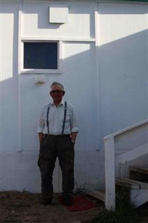
Building on two days of community visits, Sascha and I had coffee with the former mayor of Qaanaaq, Lars Jeremiassen. Lars explained to us that even if this community lives off hunting, the rich stocks of Greenland Halibut in the waters may bring more fishing to this community. The small fish and meat processing plant on the beach has become too small and investments are made to increase production here.
Lars also told that more and more corporations are coming here for mineral exploration activities. Currently there are activities in Washington Land further north. Zinc is being mapped, and Lars was hopeful that these activities may eventually bring new jobs to the community. The current rate of unemployment is 20%, and job opportunities are few.
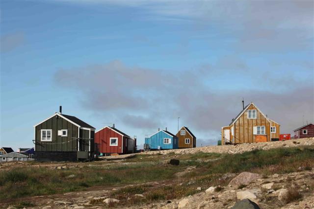
In a blue house on the main road lives Mamasu Kristiansen with his wife and a daughter. Hansigne was happily showing us that she could write the names of her entire family at the age of four. And while busy preparing for school, her father told us about his life as a hunter. He explained how he has witnessed changes in sea ice cover since her took up hunting as a 16 year old man. But he still enjoyed the free life of a hunter even if changes and Government quotas make it difficult to make a living at hunting.
Travelling home I leave a bit of my heart in North Greenland and another bit onboard the Arctic Tern. I will check this site for news and follow the adventures of skipper Grant and his lovely crew – Pascale and Valentine and the new group of guests onboard – Clive, Nick, Maurice and Paul.

Arrival in Qaanaaq

© Students on Ice / WWF-Canon


We decided to sail along Herbert Island to the town of Qaanaaq, approx. 35 miles away. There was no wind, but quickly we got into a heavy fog covering the boat and ice bergs. It took two of us to stay on watch all the time to avoid any encounters with ice bergs the size of busses. Slowly the fog lifted and we pushed the engine a bit to get to Qaanaaq.
Our original plan was to travel up to Siorapaluk, the northernmost settlement in Greenland. But we decided that we would rather have more time in Qaanaaq to do community outreach and to prepare the boat for the next leg. And finally Tim feels that there is a fair chance to discover yet another northern salt marsh on the Harward Islands close to the Greenland Ice Sheet.  We hope to report on newly discovered salt marshes tomorrow.
Sailing to the Harwards Island might bring other adventures than northern salt marshes as hunters tell us this is the preferred area to hunt narwhal. Mattak – skin and blubber of the narwhal – is a treat eaten raw and the meat is cooked. Three different hunters told us to be careful in there – but we were not sure whether they were concerned with our safety travelling in icy waters or with us getting between whales and hunters.
So far we have not had much luck spotting whales, but sitting on the deck this afternoon we saw seals. They got up to breathe and sea gulls were following their every move, circulating in order to grab any leftover fish.
Qaanaaq lays on the side of range of low mountains offering the town little protection from wind and icebergs in the Inglefield Bredning. The city, which rests on a long, sandy beach, has 600 inhabitants and probably the same number of four-legged inhabitants. During the winter the dogs are used for hunting and fishing on the ice, but during the summer they sit and wait for the cold winter to return.
Realizing that we were late for Saturday shopping, we quickly got the zodiac in the water and set off for our mission: to get fuel and fresh water for the boat, and showers and laundry facilities for the crew.
The town is fairly small and the oil tanks are situated right in the center of everything, so we started there. But people on the beach told us that the Polar Oil tank was closed for the weekend.  We found the water station near the beach and filled up our 6 jugs for water stored on deck for extra supplies, but had to leave with empty gasoline jugs. Our skipper however found that we have enough diesel to take us to Harward Islands – and importantly enough back again.
Our next mission was to find showers and laundry. In Kullorsuaq we found a community house where they offered washing and laundry facilities, so we asked around for similar facilities here. There is one in Qaanaaq too, but that too is closed for the weekend.  Still with our hopes high, we tracked down the local guesthouse to find the facilities needed. But the landlord there explained that she had had guests staying for nights in a row and that here water tanks were almost empty.  We would have to come back after the weekend.
I settled for the last, but not the least refreshing solution. Sascha and I found a stream leading water directly from the glaciers above the town to the beach. We followed the stream up to a quiet place above the town, where I cold finally wash.
Back on the Arctic Tern, we sat on the deck, enjoying the warmth of the sun. Valentine decided to take the kayak into the icy waters. The kayak has travelled with the Arctic Tern all they way from St. Lawrence, Canada to Qaanaaq without being used, but now was the time to launch it. Valentine headed off in the afternoon sun.

Getting swamped in the search for salt marshes

Salt Marsh near Dundas, Greenland. © Students on Ice / WWF-Canon


Dr. Tim Dowson joined the Sailing to Siku expedition to research salt marsh development in high latitude Greenland, in the Disko Bugt area. Salt marshes are important archives of information on changes in relative sea level from the Holocene period, as a result of their position at the interface between land and sea, their development controlled by biological, marine and climatic factors. Read full bio here.
I awoke this morning keen to start work. For a few days I’ve felt a bit pessimistic about the research.  This was despite a good salt marsh in Upernavik, and my surprise find tucked away in a cleft at the ‘Twin Islands’, a few hundred kilometers further north than any salt marsh researched in Greenland.   But the shores in the past few days hadn’t even got the plants that showed me salt marshes could grow here. However, last night we had explored Mount Dundas, the original ‘Thule’ where the community was expelled for an airbase, and  on the beach by the houses were not just plants but actual salt marsh!  By a stream and a track, which confuses the analysis, so, not the right sort of marsh – but a salt marsh nonetheless – the plants could manage with 3 months growth for each 9 months of deep freeze!  So today there was a good chance of a real find.
First we looked on the islands nearby. Mainly tidal islands, linked to land at low water. Lots of eider duck nests – now abandoned, like the houses, the chicks grown big enough to leave. Lots of healthy ‘splash’ marsh, but no protected rock clefts for a ‘proper’ one. Next to the islets further down the fjord; but Saunders Island, with its beautiful stripy cliffs, did not give enough shelter from storms.
Finally we reached the most promising site, Drowned Bay, on our route north west. This was cut into a large flat area of starkly beautiful coast, probably formed under a stable sea level a while back, just a few metres higher than the current one.  Fairly enclosed, giving protection from waves; known to be shallow, and with a stream at one end, bringing sediment which help marshes grow, everything pointed to this being a worthwhile place to look.
First the Arctic Tern had to anchor. There were more reefs near the surface than we had heard about, but we found a spot in the mouth of the bay. The onshore wind and half-metre waves started to splash us as we headed for the northern point of the bay in the dingy.  Rounding this I could see the cliff and beach offered no quarter to developing marshes, so we turned to head for the south-eastern shores, 2 kilometres away.
As with the yacht, the dingy had to slow to a crawl as boulders became numerous. The tide had dropped and the word ‘shallow’ was taking on a new meaning.  The water changed from green to a thick yellow and even lying in the bows, peering ahead to try and spot rocks in time, I could see nothing at all through it. It was now less than half a meter deep so Valentine pulled up the outboard engine and we rowed.  As we got closer to the coast, I could rule out more areas, but not the most distant – and most promising – one.
The wind and waves made controlling the dingy – clearly not designed with rowing in mind –  more difficult, and as there was ever less water depth we clambered out to pull it. But even walking was now difficult. 10 cm of water, then 10 of soft mud, and it seemed firm. But pushing down to pull on the boat gave the mud time to grip. Lifting your feet was more difficult than the actual pulling – at least if you wanted to keep your boots on. And each pull only shifted the boat a few cm. Between the four of With the erratic boat movements Mette almost fell into the near-freezing sea; filling boots with water seemed like getting off lightly. But this gave her a brainwave, so by counting out loud and pulling together, we now advanced half a meter a time. And behind us stretched our footprints and boat track in the now exposed, sticky mud.
But we felt more hopeful – we were making progress. Ahead we saw a change in the ripples on the water – maybe where the river flowed across the bay towards the sea – so maybe a slightly deeper channel where the boat might float, or we could row. And if we headed back towards to yacht, maybe I could jump out onto the small beach and go by foot to check the one possible place for a marsh. But once afloat, advance though this was, our progress remained slow. Rowing – and punting with the oars against the bottom – we moved forward most of the time, although even this was often only vaguely the way we needed, straight into the wind and the waves. And the visibility for rocks, while variable, was often low.
Finally we could use the outboard motor. Gingerly we edged towards the yacht. Further thoughts of looking for salt marshes here was abandoned – tired, wet and muddy, even if any marsh was there we would not be up to extra hours’ work it would mean, glad as we were to have avoided sitting in the dingy waiting for high tide to refloat us and let us escape.  But in any case the yacht, too, needed to move – with the extra-low tide today, and the unexpected rocks, it needed to move as soon as possible to avoid grounding itself.
What fun it is researching in poorly mapped and described areas!
By Tim Dowson
Life on board

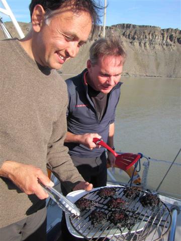
British-German team barbequing: Tim Dowson and Thorsten Milse.


As a French person, I enjoy the British way of politely saying things, for example, “inviting” us for dinner when it is their turn to cook and food is ready! Or using understatements like “Come on in, the water is lovely” after a bit of polar swimming in the bay. So a lot of teasing is going on, depending on where you are from.
I very much enjoy welcoming the 4 new crew members on board and appreciate the Greenlandic translation of Sascha, the Danish explanations of Mette about Greenland’s history and situation, the German way of taking pictures, the definitely British salt marsh scientist (and humor!).
Once we are back on board tonight, our British-German team (Tim and Thorsten) is cooking for everyone. We enjoy a first barbecue burger, but the second one is close to being carbonated…. Obviously, the British-German team blames the barbecue propane bottle, which is supposedly too weak or too strong at times! After a good laugh about it, time for some of us to enjoy the quietness, knit, go “showering” in a cold Greenlandic stream, or to do the dishes. It looks like we will all enjoy a quiet night, without watch needed.

Experiencing northern Greenland

Mountain in northern Greenland. © Students on Ice / WWF-Canon


Sascha Schiøtt is 25 years old and was born and raised in Qaqortoq, South Greenland. She has been interested in nature and wildlife since childhood, and has worked as a student at the Greenland Institute of Natural Resources in Nuuk. Here she helped with sampling data for several studies. This sparked her interest in Arctic biology and she is currently studying biology at the University of Aarhus, Denmark.
As a member of the voyage to the Last Ice Area, Sascha is helping with outreach and activities in town and settlements visited en route, including translations from English to Greenlandic and Danish.
I was born and raised in South Greenland, in a town called Qaqortoq, where the climate is with relatively mild with warm summer, temperatures of up to 20 C or more, and mild winters. Because we don’t get sea ice during the winter, there are no Huskies either. We actually also have a few introduced trees and flowers as well as cultivated farm land.
Coming from South Greenland and going up north onboard the Arctic Tern, has really impressed me, as I always get amazed at how big Greenland really is, and how diverse the nature in Greenland is. In fact some of the flowers we have seen during the trip, are flowers I haven’t seen before in my life, as some only grow in Northern Greenland. Since yesterday, we have seen a lot of little auks. They are mostly found in the high arctic, and I have never seen them in South Greenland.
What I hope to see here on this trip, are Narwhals and Belugas. They are really rare to see in south Greenland and I have actually never seen any, only what we can buy in the stores, which are sent from hunters from North Greenland. Not only are some of the animals and flowers different from what I know from growing up in South Greenland, but also the mountains seem different. The mountains here, gives me a feeling of how harsh the winters they have up here really are. The mountains up here seem to be more fragmented, as a result of glaciation and also from the frost heaving, where ice formation in small cracks in the stones makes them fall apart and therefore erode faster. This gives the mountains a more rough and fragmented look.
And it is amazing to think, that the sea is covered with sea ice during the winter and that the sun goes down for at least 3 months. All of this makes me amazed that people live this far up north, but I can also see how beautiful a place it is to grow up in and live in. Some day in the future, I would really like to experience the winter up here, experience the sea ice, the darkness and the cold. All of this makes me want this place to remain like this in the future, as these special conditions make it possible for some animals to survive and also is an important part of the big ocean and therefore the rest of the world. It is a shame to think that this might not be like it is today in the future.
 

Thule Air Base, Greenland

The abandoned site of the original Qaanaaq. © Students on Ice / WWF-Canon


Leaving Savissivik, we decided to head to our next stop right away as the wind wouldn’t leave us alone and the anchorage was not safe for a longer time. So after an hour stop, we kept going and were aiming for the North Star Bay and Pittufik/Thule Air Base. A little bit of wind, enough to set the sails and turn off the engine for a few hours, a few icebergs and here we are, actually sailing in good conditions for few hours. The crew enjoys the silence of a sailing boat, actually sailing. As the night passes, we go through our watches. The crew does 3 hours watch and the guests do 2 hours watch, everyone has to wake up in the middle of the night at some point!
By late morning, we are close to the Thule Air Base. We call them and ask for permission to come around: all right, we can anchor around the old settlement of Qaanaaq at the foot of Mount Dundas, but no permission to dock at the actual Base. Fair enough, the anchoring spot looks very nice and very well protected. So… it could be a full night for everyone. Maybe…. It always depends on the weather, the quality of the anchorage, and our obligations for the next days.

Grant Redvers climbs Mount Dundas. © Students on Ice / WWF-Canon


All happy and well fed by the beginning of the afternoon, we head on shore for a walk. Getting up the hill is kind of hard after several days on board! It feels a bit weird, but very nice. We climbed Mount Dundas, where a small and steep path with lots of rocks and scree and a bit of climbing with ropes challenged us. Very amazing landscape from the top, 220 meters above sea level: one side on Thule Air Base, the other way on icebergs, a glacier and offshore. A 360 degree landscape – every minute we all think that we are quite lucky to be here!
The Thule Air Base is a very important place for Greenland as far as history is concerned. There was a settlement here called Qaanaaq until 1953 and the Americans came during the cold war and requested the land to establish a military base. That is how 117 people “were invited” to go and live somewhere else. So the settlement was abandoned and you can see today that the old settlement houses are still there, quite in good shape actually. From the sea, we could see the American Air Base, it does look bigger than expected, and seems to be in a very good area — flat, close to the ice cap and protected.

Visit to Savissivik

Students on Ice / WWF-Canon


After more than 24 hours Melville Bay, where the Arctic Tern was accompanied only by guillemots and icebergs, we started to see land in the morning. And in the afternoon we landed by Savissivik, a small community of 74 people on the edge of the Melville Bay. We anchored by the settlement and put the zodiac in the water, carrying Sascha and I to the village to talk with the local hunters and Tim and Thorsten to check out a potential salt marsh site.
Sascha and I went to the local Pillersuisoq, where groceries can be bought. We met a hunter from the community, who told us that they just recently had their first supplies of goods and that a second ship was to arrive in September. These supplies were to last them all winter and well into the summer next year.

Students on Ice / WWF


But Savissivik is a hunters’ community and most people here live on what they hunt themselves. Hides of polar bears were hanging outside to dry and seal blubber was let on the stones for the dogs. On a warm summer day the dogs looked anything but pleased with the long wait for snow and sea ice.
We were told that hunting of seal, narwhal and beluga whales as well as polar bear is the predominant activity. Quotas for hunting of many species are set by the Greenland Government, and the hunter explained that the season for hunting of polar bear is short – often the 18 bears harvested locally are taken within the first few months of the season. While the communities further south seemed to live off both hunting and fishery, there is no fishery here yet. Changes in climate may however lead to the introduction of Greenland Halibut fishery here too.
By the harbor we met another hunter, who told us about life in the settlement. He explained that there are currently 74 people living in the settlement. We saw a number of abandoned houses so this community must have been bigger not so many years ago. The hunter also explained how they would harvest Little Auks from the cliffs behind the settlement by waving nets in the air.
Two kids were playing with dogs outside a house. We asked them about their school, and they explained how the local school ends after the 7th grade. Children must then move to Qaanaaq for further schooling.
We met up with our hunter again, building a new kayak. He explained how everything was made from wood and skin, and how he tied the pieces together using string. This makes the kayak flexible and easy to repair during hunting.

Visit to Kullorsuaq

Students on Ice / WWF-Canon


Last night we arrived in a small bay where we found an anchorage protected from both wind and ice. But as there was a risk of the exit being blocked by huge icebergs, the captain decided to introduce the first anchor watches. This gave each of us an hour to sit on the deck of the boat and look at the ice and our anchor while thinking about the past days. We are all settling into a routine here onboard the Arctic Tern and the small quarters are starting to feel a bit like home.
This morning we all slept in after yesterday’s long sailing in bad weather with waves making the ship roll from one side to another. We are all tired – some from the 18 hours of sailing and watches out in the wind, others from the first encounter with sea sickness.
Getting up this morning we saw the sun beating from a clear sky. We went on shore for a short hike, looking for new salt marshes and climbing a little hill, which gave us a good view of the bay and the Arctic Tern. And Tim jumped in the water to become the first polar swimmer of this leg. I plan to join the club, but preferably from the beach in Siorapaluk – the northernmost settlement of Greenland.
We all decided to visit the community of Kullorsuaq this afternoon, Sascha and I to speak to the population there about their experience with climate change and the rest of the crew to have a walk around town. Kullorsuaq is a growing community, which had only 9 houses when our first contact in town, Mathias, was a young man. Mathias told us how the community today has approx. 500 inhabitants.
Mathias told us that he goes hunting for narwhal and beluga in Melville Bay. He travels there by boat, but uses his home made kayak and harpoon to hunt the whales the traditional way. He took us to his house on the top of the hill to show us how he could make his own kayak in only 24 hours and we explained to us that he makes arrows for the harpoons of both bones and recycled iron and aluminum, which he also sells to other hunters. We got an arrow that Mathias had carved from reindeer antlers and will give this to the crew of the Arctic Tern for safe sailings for the remainder of the Sailing to Siku voyage.
Mathias explained how hunting is decreasing in Kullorsuaq. In earlier days he was able to hunt for more narwhal and belugas, but since then the Greenland Government has introduced qoutas based on biological advice, reducing harvest of a number of mammals to sustainable levels. Instead he explained that more and more villagers were fishing for Greenland Halibut like we saw in Tasiusaq further south.
We asked for his advice on polar bears. This morning when we went on shore we brought a rifle to scare polar bears off, but Mathias explained that it was primarily in the winter that they saw polar bears close to the community. He said that most likely a polar bear would walk away rather than attack us. But knowing that we are entering polar bear habitat now we would rather be safe than sorry, bringing along a rifle when on shore.

Twin Islands Marsh

Researcher Tim Dowson and Mette Frost from WWF-Denmark collect data on Greenland's salt marshes. © Students on Ice / WWF-Canon


Dr. Tim Dowson joined the Sailing to Siku expedition to research salt marsh development in high latitude Greenland, in the Disko Bugt area. Salt marshes are important archives of information on changes in relative sea level from the Holocene period, as a result of their position at the interface between land and sea, their development controlled by biological, marine and climatic factors. Read full bio here.
Looking at the detailed maps available, I thought I had found an area close to our planned route north where there was a good chance of finding a salt marsh. I was optimistic although no marshes have been reported this far north, as I had seen some salt marsh plants at Tasiusaq where we spent our third night.  So as it was warm enough for a marsh to grow, it was just a question of protection from large waves and ice damage.
Reaching the area took extra time, including a slow crossing of the aptly-named Giesecke Ice fiord, where the question was constantly which ice floes were safe to bump into – OK if the size of a vacuum cleaner, preferably not those the size of a fridge.  But when we reached the site, all we found we found was a small round bay with a few small bergs bobbing about, enough to destroy any marsh starting to form.   But at least I saw some more of the grass-like plants that I wanted, in the splash zone above the high tide line.  A bit disappointed, under thickening cloud on our way on to a potential mooring point for the night, I had a 2-second glimpse through a crack in the edge of an island of just what I was after – plants below the high tide line.  In less than an hour, with the help of Mette and Valentine, I had a few samples from the most important zones of this new marsh, each one ‘leveled’ to give a position in relation to the today’s sea level – crucial to interpreting the lab findings when I am back at Durham University.

Salt marshes and splash marshes

Dr. Tim Dowson joined the Sailing to Siku expedition to research salt marsh development in high latitude Greenland, in the Disko Bugt area. Salt marshes are important archives of information on changes in relative sea level from the Holocene period, as a result of their position at the interface between land and sea, their development controlled by biological, marine and climatic factors. Read full bio here.
I am now on the last leg of my own journey to meet the Arctic Tern at Upernavik, some 200 km north of here. I had a chance to have a look at the coast near to the airport here at Ilulissat yesterday, and while there are lots of salt marsh plants to be found in small clumps, there is little genuine salt marsh as such. This is a ‘high energy’ coastline, both because of the ‘fetch’ – Disko Bay and Baffin Bay beyond it meaning large storms, or even just waves, can batter the coast – and also the hundreds icebergs, large and small, that make Ilulissat so special, can erode away any salt marsh that starts to form, or when rolling over can send big waves which can do the same. So what I’ve found is really ‘splash marsh’ rather than salt marsh proper. I hope to have a chance to look in another, more sheltered bay slightly further away shortly, before my plane leaves – anything I find here will be a bonus but will help build a picture of how sea level has varied in West Greenland over the recent centuries. I’m really excited by this chance to extend our sea level research further north up the coast – as well as to the journey, places and people I will meet, in their own right.
I was told yesterday that it was the first day of autumn here – the weather a bit cooler, with some cold rain at midnight, and fog preventing planes from flying. Certainly a contrast to the 2 weeks of hot weather I had recently further west in Disko Bay, a stark contrast to the torrential rain that stranded my wife across the city from our home in Newcastle, England recently. Unseasonable weather in both places, with the loss of a major bridge at Kangerlussuaq, an important airline hub in Greenland, not because of heavy rain but through hot weather meaning more ice sheet melting has taken place than normal, and the river filling up much more than in the past. These events strike an ominous chord alongside a scientific report I have heard about this morning apparently predicting the loss of all summer ice in just 4 years. This will have dire consequences for local people, wildlife, and also for the world in general.